
Canning Town is a fascinating area of East London with a rich and diverse history. From its origins as a marshland accessible only by boat or toll bridge to its industrial hub and multicultural community development, Canning Town has witnessed many changes and challenges over the centuries.
One of the most significant events that shaped Canning Town’s history was the opening of the Royal Victoria Dock in 1855. This was the first of London’s docks designed specifically for steamships, which were becoming increasingly important for trade and commerce. The dock attracted many businesses and workers, especially from the shipbuilding, chemical and sugar refining industries. The dock also brought in a wave of immigration from various parts of the world, creating a vibrant and diverse population.
However, the rapid growth of Canning Town also came with problems. The area suffered from poor sanitation, overcrowding, disease, frequent accidents and explosions from dangerous industries. Canning Town became notorious for its slums and poverty and was often visited by social reformers and journalists who exposed the harsh realities of life there.
Canning Town is a district in the London Borough of Newham, East London. It is located north of the Royal Victoria Dock and has been described as the “Child of the Victoria Docks” as the timing and nature of its urbanisation was mainly due to the creation of the dock. The area was part of the ancient parish of West Ham, in the hundred of Becontree, and part of the historic county of Essex. It forms part of the London E16 postcode district.
Canning Town is a diverse and multicultural community with a population of over 42,000 people. The area has many businesses, shops, restaurants, and cultural attractions. Canning Town is also a central transport hub, with two London Underground stations (Canning Town and Custom House) and several bus routes.
The area is undergoing significant regeneration, with several new developments underway. These include the new ExCeL London exhibition centre, the Emirates Air Line cable car, and the Stratford Waterfront development. Canning Town is also home to the University of East London’s Docklands Campus.
Canning Town is a great place to live, work, and visit. It is a vibrant and diverse community with a lot to offer.
Despite these difficulties, Canning Town also had a strong sense of community and culture. The area was home to many social clubs, pubs, music halls and sports teams, including West Ham FC, which originated from the local ironworks. Canning Town also produced famous figures, such as boxer Terry Spinks, who won a gold medal at the 1956 Olympics, and singer David Essex, who grew up in nearby Plaistow.
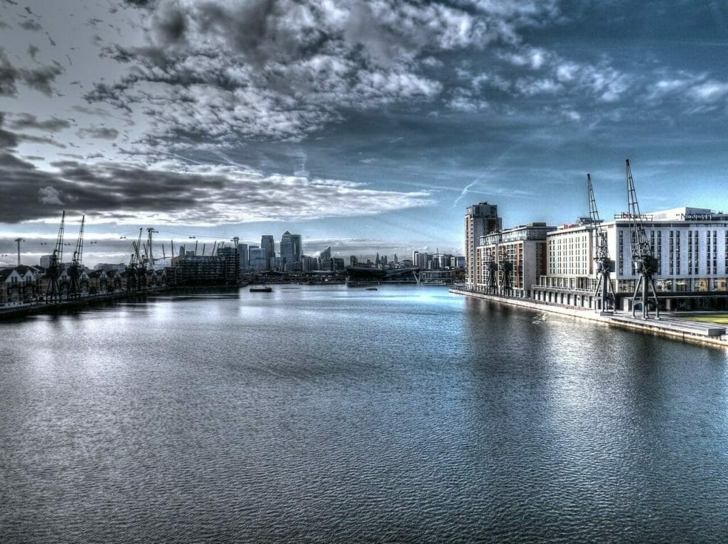
Today, Canning Town is undergoing a significant regeneration programme to transform the area physically, socially and economically. The programme includes building new homes, creating jobs and improving transport links. The Royal Victoria Dock is now part of London’s Docklands, a modern business and leisure district that includes Canary Wharf and the Excel Centre.
Visit Canning Town in East London.
Canning Town is an area that has always adapted to changing times and circumstances. It is an area that offers visitors a glimpse into East London’s past, present and future.
Like large parts of the East End, Canning Town once had a strong industrial heritage, but the area was originally marshland. As such, for many centuries, the only way to reach Canning Town was to boat or pay a toll bridge. The location opened in the early 19th century when the Barking Road was built, bringing a more prominent bridge and more opportunities for connections with the rest of East London.
Before the reign of Queen Victoria, Canning Town had no real significance and only got its name in the Victorian period. It is probably named after Charles Canning. At the time, he was a relatively famous and popular character and had successfully managed the Indian Mutiny as Viceroy of India. Once the area started to be developed, it became a busy industrial and commercial hub.
For example, in 1846, the North London train line brought higher levels of industrialisation to this area of the East End. Originally built to transport supplies from the local docks, the Barking Road passenger station’s opening and more housing construction attracted more workers to the area’s chemical, shipbuilding and sugar refining factories. The football team that started in the local ironworks famously went on to become West Ham FC.
By 1855, Canning Town had a new Royal Victoria Dock. However, the local water supply and sewage system must be designed to cope with the increasing residents and businesses. Canning Town became infamous for its slum living conditions, high poverty levels and outbreaks of smallpox and cholera due to its inadequate sanitary conditions.
Canning Town Forges
Canning Town is a district in East London with a long and fascinating history of industry and innovation. One of the most prominent examples is the Thames Iron Works, a shipbuilding company from 1837 to 1912. The ironworks was located on the banks of the River Lea, near the Royal Victoria Dock, and produced some of the most advanced warships of its time. The ironworks also had a social and cultural impact on the area, employing thousands of workers from different backgrounds and countries and founding the West Ham football club.
The Thames Iron Works was not the only forge in Canning Town. The area was known for its metalworking and engineering industries, which attracted skilled artisans and entrepreneurs from all over Britain and Europe. Some of the notable forges in Canning Town were:
- The Canning Town Forge was established in 1857 by William Henry Piggott, a former manager of the Thames Iron Works. The forge specialised in making wrought iron pipes, fittings, valves, and boilers for gas and water supply. The forge also produced ornamental ironwork, such as railings, gates, and balconies.
- The Victoria Forge was founded in 1865 by John Penn and Sons, a leading marine engineering firm. The forge manufactured steam engines, boilers, propellers, and other machinery for ships and locomotives. The forge also supplied parts for the London Underground and the Channel Tunnel.
- The Britannia Forge was set up in 1872 by James Ashcroft, a former employee of the Thames Iron Works. The forge produced iron plates, bars, rods, and beams for shipbuilding and construction. The forge also made iron bridges, roofs, girders, and cranes.
These forges contributed to the economic growth and development of Canning Town and its reputation as a centre of excellence in metalworking and engineering. However, they also faced many challenges and difficulties over the years, such as competition from cheaper imports, labour disputes, environmental pollution, and technological changes. By the early 20th century, most forges had closed or moved away from Canning Town.
History of Canning Town’s New Docks

The increased docklands and shipping activities brought in a new influx of local and overseas workers who needed housing, including a significant community of West African, Caribbean and Asian immigrants. At one point, Canning Town was home to the most prominent black community in London, with over 100 families.
Many of the capital’s more dangerous industries were historically located in the East End, safely out of the way of the city of London and its more upmarket central areas. Charles Dickens described some of these industries as “offensive”.
This probably relates to the smells they created, as local businesses worked in gut spinning, varnish production and oil boiling at the time. Operating outside the city’s regulations also made it easier for companies to ignore housing and business regulations, sometimes leading to accidents.
Canning Town was no exception to this rule, and the area was affected by a significant accidental explosion at an ammunition factory in nearby Silvertown. Although this accident resulted in a relatively low loss of life, it damaged tens of thousands of local buildings around the East End.
Housing in Canning Town
By the 1930s, housing conditions in Canning Town were so dire that the local council started a program to clear the slums and provide better social conditions for residents. Many slum properties were torn down, and new houses, nurseries, medical clinics and even a lido opened.
The Second World War also severely affected the area and led to further redevelopment initiatives after the war. Much of the East End was a prime target for German bombers, and it is estimated that over 85% of the local housing stock was destroyed.
Canning Town was also the scene of one of the worst bombing events in the war, although a government cover-up at the time hid the full extent of the incident. In September 1940, residents were sheltering in the basement of South Hallsville School during an air raid. They were staying in the school because they had been evacuated from their homes.
The school suffered from a direct hit burying all the sheltering locals under piles of rubble. Reports at the time indicated that around 70 people died in the incident, but it is now believed that close to 600 people died on the site making this the worst civilian casualty rate in a bombing raid during the war.
Modern History: Canning Town Redevelopment
Due to redevelopment programs and damage sustained in the war, much of the housing in and around Canning Town is relatively modern; most rebuilding took the form of new council estates, including several high-rise tower blocks, which were popular at the time.
One high-rise block became well-known in the 1960s for all the wrong reasons when a gas explosion caused an entire corner of the block to collapse. It and its surrounding high-rises were demolished to make way for safer, smaller houses, and the lessons learned from this accident changed how high-rises were built. Canning Town remains a relatively deprived area and is undergoing continuing redevelopment.
Hello Tom Garnell
I remember you and your brother (Tony?). You lived in a flat looking down on Killip Close Hall that was hired out for events and used for Mass on Sundays. I remember you working at J & N in Carpenters Road E15 in the laboratories, I worked there too – in the Stats/Wages office. You were a year or two older than me so you would have known my sister Valerie better than me. We both went to St Helens Convent School in Bethell Ave and later St Angelas Ursuline Convent School that I left in 1962. You really did go up in the world with a wife from Ilford – that was probably still in Essex then. I moved out of London in 1967 and I used to return occasionally to visit family but now I no longer do. Each time I did go I was saddened by the changes so I now prefer to remember it as it was – a much better place.
Beryl Wade, ex Morgan St. E16
Hello Tom
I remember you and your brother (Tony?). You lived in a flat looking down on Killip Close Hall that was hired out for events and used for Mass on Sundays. I remember you working at J & N in Carpenters Road E15 in the laboratories, I worked there too – in the Stats/Wages office. You were a year or two older than me so you would have known my sister Valerie better than me. We both went to St Helens Convent School in Bethell Ave and later St Angelas Ursuline Convent School that I left in 1962. You really did go up in the world with a wife from Ilford – that was probably still in Essex then. I moved out of London in 1967 and I used to return occasionally to visit family but now I no longer do. Each time I did go I was saddened by the changes so I now prefer to remember it as it was – a much better place.
Beryl Wade, ex Morgan St. E16
my name i roy hare.i lived at 12 wade road custom house until my family moved to Dagenham in 1949.my dad was sidney hare my mum was maud evelyn hare my sisters where diane hare janet hare rita elizabeth hare and sharon.hare.if there are any people that may have
news regarding my post please contact myself..many thanks.
Hi Roy, I don’t know the name ‘Hare’ In Custom House back in the 1950s 60s Most of us got to know each other either by sight or friendship.. So, I don’t know the time period you reffed to, I’d probably know you by sight If you refer to that period, I used to live in the Moorings Prince Regents Lane Custom House opposite Becton Rd Park Then after we were bombed out in 1942 ..Council moved my parents to Shipman road (further along towards the docks) ! I spent many years there and I went Girst to Rosetta rd school and to Shipman Road School..
We Now live in Essex, Lovely peaceful and safe !
All the Best Roy, Hope you find someone to chat to ….
Hi Roy
How many houses were in wade rd? That’s where my dad was born and my Nan lived there until 1977
Hello Jenny,
Your enquiry as to how many houses in Wade Road, there were 31 houses. In the 1891 and the 1901 Census it was called West Road. By the time of the 1911 Census the name had changed to Wade Road.
in reply to an earlier comment you said, “The area shows on the 1850s OS map” and I was wondering where you found this map. I am trying to find the location of a running ground that I believe was in Canning Town in the 1850s. it was called the Royal Oak Grounds, associated with a pub called the Royal Oak. the ground was active from 1851 to around 1854 when the landlord changed. the pub was in the Barking Road near what was then called Barking Road Station but which has since been renamed Canning Town station. I “think” the running ground was in the triangle of ground between Stephenson Street, Barking Road and Star Lane, approximately where Malmesbury Road Park is today, but I have been unable to locate a map of the appropriate period to confirm this. are you able to offer any further information on this period.
thank you,
Martin
Hi Martin. I can’t help you with your enquiry But the Mention of Canning Town spurred a few memories from my early days, We young Custom House mob used to jump on the train at Custom House and get off at Canning Town, We’d cross the road and try to ‘ Bunk In “ the side doors of the Imperial Cinema opposite the station,
One would go in. And slip around to the side door and let the rest of us in ! We never had the sense to go in one at a time. The whole lot of us would all appear at one of the exit doors En Mass … only to be turfed out of the front door to the astonishment of all the courting couples in the back row, they were fond old memories of the days just after the Second World War ended,
Take care Martin From Ray of Epping Essex Having moved from Shopman Rd around 1965
Having Earlier been bombed out of the Anchor Houses flats in Prince regents lane Custom House E16 , I was two when the bomb hit Luckily I was over the becton rd Park with my mum,
Or you wouldn’t be being pestered by the superfluous Email …
Hello Martin,
The 1850s Ordnance Survey 25inch maps we’re surveyed in 1867 and published in 1867 and are online free to view with the National Library of Scotland.
The piece of triangle of open land in your inquiry of a running ground was between Barking Road, Star Lane and a small short lane (not a through road) called Victoria Place at the far end of the triangle.
At that time on the map the public house is not there but there is what could be some sort of farm building nearby and the whole area was very rural.
The public house does show up as a PH on the corner in the next edition map in 1893 and published in 1895, now the area is very much built upon with lots of housing in the area.
Where I said Victoria Place was it is now called Cross Street making up the triangle with about 25 dwellings including the public house on the corner within.
So now we have Barking Road ( straight) Star Lane ( angle ) and Cross Street ( angle ) making the triangle where the original field was (running ground).
In the next map edition in 1913 revised in 1914 and published in 1919, Cross Street is called Clove Street, this could be an error or it might have been renamed as Clove Street like some others in Canning Town about that time.
Hello Martin,
Some more information to help you with your enquiry.
The Royal Oak was a lot further down the Barking Road, on the corner of Oak Crescent other than being near Star Lane.There was a large rectangular piece of land ( marked with no.533) on the corner by the railway station, which could be your running ground which was triangular pointed but separated by a short distance from the Royal Oak.
This appears on 25 inch OS map London (First Editions c1850s) XXXV111 Surveyed:1867, Published:1869 (National Library of Scotland)
On the same map there also was a small rectangular area (marked with no.277) enclosed with trees (size of a football pitch) situated very near but not attached to the rear of the Royal Oak.
Today Oak Crescent is situated on this area, that also could have been connected to your running ground.
In the next edition map you can see the area that was marked no.533 is now very much built upon – 25inch OS map Essex (New Series 1913) LXXXV1.9 Revised 1914 Published 1916 (National Library of Scotland).
In my first message the pub on the corner of my suggested triangle of land which I described with Star Lane and Barking Road was The Princess Alexandra Hotel Barking Road opened in 1867.
This does not appear on the first 25inch OS map London (First Editions c1850s) XXX1X Surveyed: 1867 Published: 1869. ( National Library of Scotland ).
But it does appear as a PH on the two later maps –
25inch OS map London (Edition 1895-96) LXV1 Revised: 1893-1894, Published: 1897.
25inch OS map Essex (New Series 1913) LXXXV1.10 Revised: 1914 Published: 1919.
(National Library of Scotland).
The first landlord at The Princess Alexandra Hotel was Charles W Nicholl and is first recorded at the Post Office in 1867 and was there until recorded in 1882 (Kelly’s Directory).
In 1967 it was demolished and rebuilt across the Barking Road and now Star Lane is renamed Newhaven Lane.
Greetings Ray,
Thank you for your lovely response to my earlier message. I pulled out some of my Mum’s old school reports from Shipman Rd and Mr.Bell was the headteacher listed. My mum was a much better student than she let on.
I am still looking for any general photos of the custom house/silvertown area especially the shops close to Randolph Rd and Prince Regents Lane school from the 1960’s. I have looked on Pintrest and the London Picture Archive but there are very few. Have you had any luck with photos from this area?
Our house in Randolph Rd was under compulsory purchase and then demolished with others on the street.
Dear Tracy, In answer to your first request, Sadly No I haven’t a shred of picture history of The times that I was there in Shipman Road School nor of the surroundings, Not many people had Cameras in those days, The WAR had only just ended And We had recently been bombed out in Price Regent Lane Anchor Houses,
I used to go to school And got registered in by the teacher. And then wait until we changed classes And ‘ slip away ‘ for the day, I’d often spend most of the day going back and forth on the Woolwich ferry , till I got kicked off by one of the crew .. my dad was a lorry driver Working for the C.W.S ( Co – Op Wholesale department,) He’d often pick me up just around the corner from the school gates and I’d go with him delivering all over the Country !
By now I was about 10 / 12 years of age, Some Parents Were not very responsible back in the 1950s. We were too busy playing on Bombed sites to worry about Education or School…
I remember Larkin’s Sweet shop and Gobells ( the grocery shop next to Larkins )
I remember going around to Freemasons rd to get freshly backed bread You could smell the backers from three streets away .. I will never forget those lovely hot rolls and crusty bread with butter or dripping on them,
Percy Bell (The Head master at Shipman Rd school ) Was a tall slim man I remember him well as I was often given “6 of the-best” for absconding school lessons,
I remember Mr Barron and Mr Turbaville ( probably spelt his name wrong ) And the Lovely Miss Evans (The Music teacher), Lovely days to remember, The school was very large Several stories high with huge playgrounds ( one for Girls and one for Boys )
I once drove back there from Essex And couldn’t believe how small those “huge” playground really were, The school is now gone So is most of the streets that I remember , Varly Rd
Alnwick, rd Chauntler rd, Cundy rd Gresham Rd Lay’s Rd And I remember going to the seaman’s mission ( The flying angel ) in Victoria dock rd We used to sneak in and watch the films occasionally. The building is still there , but now a series of Flats .. I can actually remember the Tidal Basin Station after it had been bombed and we used to play on the bombed out Tidal Basin Tavern pub ( outside of the station,) That also took a hit on the same day , probably from the same string of bombs that blew up the rail station across the road, I could go on reminiscing My main recollection of my childhood days was “ Hopping down in Kent “ in a beautiful little village called Chilham ( near Canterbury ).. We often drive don there and sit outside the pub where my late Parents used to drink, The East End Kids would sit outside with a bag of crisps and a shandy ! (No parental control in the 1950s for many of us). Anyway enough for now, Look after yourself Tracy … Keep safe and keep happy … Love and best wishes from Ray Hill now of Essex Once of Shipman Rd 1950’s
We moved out of London about 1970 …. Don’t recognise East London now ! ITS GONE
Bless its heart and all of its memories… RAY
My grandparents lived in Canning Town until their house was bombed. George and Phoebe Williamson, he was a blacksmith and farrier. They lived in Scots Street, I am assuming that does no longer exist, also I think the forge was in Star St.
Any information on those locations would be great?
It might have been Star Lane Not star st. Just trying to reduce your search area. I don’t personally recall a Star st !
I could be wrong . Just trying to be helpful in your search for info … from Raymond Hill Shipman road School Custom House. We were bombed out of our flat in the prince regent lane during a bombing raid on the London Docks .. circa 1942. We were then given a house in Shipman Road Custom House I remember the “Head”Family
And the ‘Chisnells’ From Ray hill…
Thank you, it could well be Star Lane!
That was a simple search 1939 register
6 Scott Street, was located west of Hallsville school, running north to south, all that area got devastated by German Bombs including the school
Are you any relation to Mervyn?
George J Williamson 24 Nov 1892 Male Farmer Married 3 1
Phoebe (A C) Williamson 15 Jun 1891 Female Unpaid Domestic Duties Married 3 2
George William Williamson 05 Oct 1915 Male Warehouseman (Grocery) Single 3 3
Phoebe Mary Jones (Williamson) 05 Sep 1917 Female Tin Labeller Paint Factory Single 3 4
Walter James Williamson 24 Dec 1920 Male Warehouse Hand (Grocery) Single 3 5
Annie Howland (Colter) 04 Sep 1915 Female Tin Filler-Paint Factory Single 3 6
Surprising there’s a Picture: https://www.pinterest.com.au/pin/35536284533520010/
PS on the register George is listed as a Farmer, falls well into his job as a Blacksmith Farrier, but close look at the original hand written 1939 register he’s listed as a Farrier Heavy Work, that’s the man.
Hi,
My grandfather Charles Wooldridge in was born in 1901 and lived on Dartmouth Road.
He later moved to Dublin in the 1920s and married my grandmother. We know nothing of his family. Does anyone have any information about the family name Wooldridge.
Albert Wooldridge
Hi Albert. I cannot help you with the name Wooldridge I wish I could As it is a fascinating subject to find info on people that were entwined within your families history …. Hope you have success with your search .. Take care .
Ray Hill ( A Custom house resident until 1970 ) Now in Essex ..
Hi Albert, my best friend during my teenage years was June Wooldridge. We would both be just turned 80. June had two younger brothers – Melvyn and John. The family moved to Chatham around 1956/7.
Unfortunately I no longer recall June’s parents names or the name of the road they lived in. It was a maisonette in Canningtown somewhere between Hallsville Rd school and Rathbone Street.
Just checked on the map and found Radland Road. That is where the Wooldridge family lived until the move to Chatham.
Hi Alan, My Dad (Stephen Bruns) is also Dennis and Colin Crumps cousin there Mum (Genie) is my Grandads Sister who was Sidney Bruns and they all lived in Marlesbury Road, and later moved to Exining Road. My dad is the eldest of 5, then Keith, Geoff, Angie and Brian Bruns. I remember Colin who was lovely and spent a lot of time with us over the years.
Any relation to Micky Bruns my old mate been cleaning shop windows in Chingford for the last 50 years must be my age, 75, sister Julie married Charlie and lives in Kent?
Hi Graham,
Yes Mick is my Grandads brother, he married Edna, is Julie your sister? as I am pretty sure my Grandad never had a sister called Julie, or is that your sister?.
Julie is Mick’s sister, their dad was Archie and mum Renee, Julie worked for my dad as a secretary for a few years and they lived in Meadow Close Chingford. I used to give Julie a lift home as I lived around the corner in Echo Heights. We worked in Hatherley Mews Walthamstow.
I was only 7 when we moved from Cambus Road in 1973, but I clearly remember Goddens as well as Hughie and Doris.
Hi Sarah,
I hope you are well. I work for Eastside Community Heritage – we are a charity based in Newham who work to collect and share the history of East London. We are interviewing people about their memories of home in Canning Town in the 1960s and 70s, particularly around Kildare Road, for our new heritage project. Might you be interested in being interviewed?
Best wishes,
Freya (Eastside Community Heritage)
HI its me again , I have in the pictures Hazel Burks uncle his name was Lenny he used to
have racing birds in his back yard .
HI thanks for the feed back I also live in North America and have done for the past thirty years,
it was only after looking through some old albums that I realize how important that these pictures
would have.
looking at our mothers when they were young and we were just east end kids with our futures ahead
of us.
let me know how I can get these pictures to you , they show a lot of fancy dress .
I lived at 45 Carson Road and have in street photos of the children and mothers sitting at the
tables celebrating the coronation .
If they are of interest to anyone I will try and get them posted.
Hi Terence, I’m Christine Burns (Birth surname). I lived in Malmesbury Rd & vaguely remember the coronation street party as a very young child. To see some photos would be great
I remember you Terry. I lived at Number 15 Carson Road. I can clear remember your dear old mum as well. I was recently messaging Linda Thompson (Georgie Thompson little sister). Linda now lives in the USA. She is still in touch with Hazel Burk who lived next door but one from you. Bill Smyth.
Bill Smyth. .. Good Morning
Thanks for taking the time to reply
Have a great day
Bill Smythe, you mention about Rathbone market .. do you, or does anyone remember the fruit and veg stall run by my grandfather, Richard Hughes and then his daughter, Edie Hughes …?
No I’m very sorry I don’t recall them. In old Rathbone street market there were a number of other greengrocers stalls but as I always worked from the shop in Cambus road I never got to meet many of the other stall holders.
Hi Janice. I do. We shopped at Raffi every week my mum bought all her fruit and veg there. I have very fond memories of that place.
Hi Glen. I didn’t live in Canning Town as such, but in a little bit of Denmark St. just off the Becton Rd. Strictly Plaistow. But adjacent to Custom House and Canning Town. In late fifties/early sixties went to school with Barry Godden from Goddens. Think he started with me at South West Ham Tech, but we ended up in different classes so lost track. My sister in law lived in an upstairs flat in Kildare Rd and I have a bit of movie of the road decked out with flags and bunting for the silver jubilee
Good Afternoon Glen and Roger.
Although I lived in Carson Road I actually worked in the greengrocer’ s with Hughie Purdey and Doris. Doris was the daughter of Sal and Jim Thake. In addition to the shop they also had two stalls in Rathbone street. Sal and Jim worked there. Doris and Hugh had a son called David. We went to school together. I think David took over the stalls in the market once Sal and Jim retired. Jim was a cousin of the Thake family that had the wet fish stalls in the market.
Hi Bill ,
My Mum used to go to your greengrocers and take me , then when I was older I used to go by myself to see ‘Aunt Sal’ . I lived in Kildare , and my Nan would take me weekly to the newsagents opposite the greengrocers . She would buy me ‘Radio Fun’ and ‘Film Fun’ (dates me) , and put some money away on a ‘card’ to get the respective Annuals at Christmas .
HI Nigel ,
I went to South West Ham Tech. 1957-1962 , and spent most evenings going to get something for my Mum from Goddens . I was always given sixpence and Mrs. Godden always got the liquorice box out to choose 6 ‘sticks’. Living in Kildare , it was our go to shop. I remember Barry who was obviously younger than me , and Derek Godden who was either slightly older or younger . I lived with my parents in an upstairs flat . I lived there till 1966 , but my parents were there from the war years until my Mum died in 1974. I wonder if I knew your sister in law . Happy Days.
Hi Brian. ‘Fraid I’m at bit younger than you, born in 1950. My sister-in-law lived in Kildare from ‘74 to ‘78. Goddens wasn’t “our “ shop, but the general store and post office corner of Ravenscroft and Carson?? Rd just off New Barn St. was. And the little chippy in New Barn St. leading to the old Becton Rd. Chips wrapped in newspaper and old pennyworth of the fried scrapings. Never tasted so good. Kids today no idea of what their missing. !!
Hi Nigel,
We were also a big customer at the Post Office . ‘Aunt Daisy'(Miss Holborn ?) who owned it always gave my Mum a packet of tea , and gave me a box of crytstalised orange and lemon slices every Christmas . I also agree with you , it was a great fish and chip shop . My last 2 years at South West Ham Tech must have been your first two . Seems a long time ago , thats because it was !!
Hi Nigel Yes the Denmark st area was quite a posh area compared to Custom House, or what there was left of it Once all the bombs that missed their target ( The London Docks ) , It was like one huge bomb site …. We were bombed out in the anchor houses in Prince Regent lane …
I have a picture of the WW2 VE celebrations in Canning Town 1945. I had some names identified for me of the people in the picture by this site, but I cannot locate the thread now and wish to discuss it further with that person.
Can anyone help with the id parade it included the following names:
Kathleen Wilson
Jimmy Penn
Peter Penn
Terry Spinks
David & Michael Formalls
Doris & Joyce Felton
Mrs Chilcott
Terry Spinks Was a well known Boxer He also had a sweet shop near the Abbey Arms.
My mum used to have a new three piece sweet every few months. I was so proud Until I found out the shops were taking them back for none payment . R Hill Epping …
The only help I can offer is that all of the people you mention lived in Morgan Street where I lived too.
All those you mention lived in Morgan Street where I lived at number 88 next door to Terry Spinks at 86.
I lived next door to Terry Spinks and I recognise the name of all who you mention. How about Brian Johnson – next door to the Formalls? I could name many others by the number of their doors in Morgan Street including the Earnalls, Roberts, Linton, Bluett and the Days – Charlie Day was the milkman.
Seeking information on Canningtown, the workers houses and living conditions in 1913 pre WW1? Also a a stone carving factory in that area at this time? It is a BIG ask I realise. I am in Australia and researching that area and period which is unknown to me. The Times History of London shows many West Ham industries from 1900 onwards, however I am not sure if stone was carved in that area (stone from Dorset, I’m thinking and presume it would come by barge?) If not where would stone be carved? Could anyone direct me to this info or any on this area and time?
Hello Kay Crabbe,
West Ham industries. Stone Carving in the late 1800s, it was in the West Ham district / Stratford High Road area that there was a Stone Works. It was in Sugar House Lane amongst other factories nearby – Asphalt works – Printing & Ink works – Boiler works – Cork works – Blue works. It was on a inland island surrounded by the Three Mills Wall River, the Bow Back river and the Three Mills Back river, near to the river Lea.
It was situated there in the late 19th Century because of the access to wharves for incoming sailing barges from Dorset and Cornwall. It may have had connections with the Thomas & Theodore Druitt & Co a family of Stone Masons that had two premises nearby in Stratford High Street from the 1830s, next to the Peg’s Hole Bridge and another about 200 yards further up by a viaduct on the same side of the street. They were both situated alongside a wharf with a crane and were there on Stratford High Street before the Stone Yard was built in Sugar House Lane.
The area shows on the 1850s OS map and by the 1894 OS map the Stone works is shown opposite the Blue works at the south end of Sugar House Lane. In the 1913 OS map a larger building was built there at the Stone works. Further down on the map about a quarter of a mile away, on the corner of Three Mills Lane next to a bridge there was another yard called a Monumental Moulding Works with a wharf alongside the River Lea.
This all fits in with the following information about the Stone Mason’s Druitt & Co. with a Stratford High Street connection, not far from Sugar House Lane. It is a excellent article you can find on Google or Safari – [Druitt dynasty of stonemasons, East London and Essex active 1810s – 1950s]. It will give the short story of the Druitt family that operated Stone Carving up to the 1950s.
Today in 2022 the area is called The Sugar House Lane Business Centre and is in a Conservation Area.(Kay, if you Google or Safari it shows info and the Stone Works on a 1894 map) — [ Sugar House Lane Conservation Area. London Borough of Newham.
Hello Kay Crabbe,
Canning Town pre – 1913 most of the workers could not afford to rent a whole house, so it was quite common to have 2 or more families living in the same house. One family would be downstairs and the other upstairs. Some of the houses lacked running water and toilets and would have an outside toilet (privvy) and a tin tub for a bath, filled with water by hand. Canning Town housing in 1913 was vastly crowded with a maze of streets with poorly built terraced houses/cottages with a door sometimes opening onto the street.
In the 1911 Census it is found that even a family that occupied one house it was quite common to take in a boarder to share the running costs. After 1919 all new houses built had to have plumbing, a water tap, sink, and toilet inside.
If you Google BHO – British History Online. West Ham: Domestic Buildings you can find more information about this reading through it from the 1840s, about West Ham / Stratford / Canning Town etc.
Also if you Google BHO – British History Online. West Ham: Industries you can find more information about the Stone Masons, regarding the Druitt family that was in the Stratford High Street. The paragraph is ‘Building Materials, Abrasives and Glass’. This will add more details about Stone Masons and the other industries in the Sugar House Lane and Stratford High Street area, as in my previous email today.
Thank you, William, you have been most helpful.
I’d found Druitt’s stone works story on Mile End Rd and Stratford, however I hadn’t read anything about a wharf and crane, that’s perfect. Would that wharf be on the River Lea or another waterway do you think, such as the Three Mills Wall River or the Three Mills Black River. I’m trying to get my head around the viaduct set-up. I’d also imagined that the Druitt High St was a long way from Sugar House Lane – to take the stone for carving – although you say it’s not far? I wonder if both places were carving workshops? I think the Sugar House would work best for my story. Much appreciated.
Your description of Canning Town is great, and I have two questions in my head. Could you suggest a couple of street names in Canning Town likely to have these worker’s homes? The article mentions street names, however I’m not sure if they are near (walking distance) to Sugar House Lane stone factory. To Google distance I need street names, so I go around in circles with this. Also, would the maze of roads and (narrow laneways I imagine) be cobblestones, or dirt in 1913 do you think? This is for a children’s novel set mostly in Australia, however I want the boy to come from this Canning Town area and working young (13) and I’m a stickler for factual history. I’m grateful for your help. Many thanks.
Hello Kay,
Thank you for your response and I hope this again helps to clarify some of your queries.
The Ordnance Survey maps I have access to online are better than the ones in the Sugar House Lane article, so I am looking and seeing the actual clear and a bigger, wider view of the detailed map area’s we are discussing. This is how I obtain my information amongst the different date issues of OS maps.
The proximity of the Stone Yard in the High Street and the one you favour in Sugar House Lane were very close, it was about 180 – 200 yards. The Stone Yard in Sugar House Lane in the 1894 OS Map was built later than 1867 and the word crane was not included, In the different later editions 1894 OS and 1913 OS maps, the name Stone Yard is only mentioned. I am sure they all from then all would have had a crane because they were beside a waterway / wharf.
In the Stratford High Street where the Stone Yard and crane is shown it runs at right angle to and is at the entrance to the Sugar House Lane area. It is a few yards away on the entrance of The Three Mills Back River and not on the river Lea. It is the Bow Bridge that crosses the river Lea.
In 1913 some of the streets would have been rough and would have had large pebbles and gravel compacted and flattened into the ground such as clay etc by large heavy rollers pulled by horses. But not all, some had cobbles and many roads were laid with various other materials such Asphalt, Macadam, Stone etc nothing was standard.
I can name a few streets very close to Sugar House Lane such as Roberts Road, Beck Road, Godfrey Street which appear on the 1894 OS map. Godfrey Street is still on the map today in 2022.
In Canning Town the nearest streets within walking distance you required to Sugar House Lane in 1894 were Florence Street, Sheppard Street, Blanche Street, Chargeable Street and they are all still there on the map today.
Good luck with your novel.
Thanks William, I’ve just found your reply and since it’s 11pm here, I’l have to some back to it tomorrow.
I hadn’t turned up any good Ordinance maps, however I will try again and check out those streets you mention. Your info is most welcome and appreciated and I’ll let you know.
Hello William, You have been most helpful and I am back with one last query (I hope).
My lad living in Beck Rd has to get to the stone works in Sugar House Lane in 1913. Looking at that map, I think he would have to go from Beck Rd up Abbey Lane, past the Timber Yard and onto High St turning left. I’m confused here as to whether there is a bridge to cross over Three Mills Wall River or does the High St Rd continue over a bridge with a walking path. Would you know this? Many thanks. K
Hello Kay,
You are nearly there with your understanding of your lads walk to work and I hope this helps. It was about a total of only a half a mile from Beck Road and it was a footpath all of the way along the High Street.
You are quite correct in entering the High Street from Abbey Lane and then turning left. There was on that corner a bridge he would immediately cross, called The St Michael’s Bridge which crosses over the entry to the The Three Mills Wall River. Then he would progress along the footpath a short distance of about 20 yards and then walk over the St Thomas D Akers Bridge (which crosses a small waterway that is fed into the same river). Then it is a short walk to the Sugar House Lane entrance (40 yards) and turn left down to the Stone Works.(180 – 200 yards)
There were no alleyways or footbridges he could have shortened his journey that appear on any of the maps, the area was surrounded by marshland and waterways etc.
This information I have obtained from the 1867 Ordnance Survey Map. The St Michael’s Bridge and The St Thomas D Akers Bridge are not named on the 1894 and the 1913 Ordnance Survey maps but are shown on them.
Yay! William,
I felt sure the marshes couldn’t be penetrated and my lad would have to take the Abbey Lane route. ( ha! now I keep seeing the Beatles striding across Abbey Road in my head).
I didn’t pick up on the smaller waterway on the High Street, so thanks for your thorough search and distance notes. I’ve turned up an excellent article on the living conditions at that time, so I’m done with Canning Town. My story has to flash to Dorset around the stone quarries at some point and I’m hoping that proves simpler. Regrettably, we didn’t visit either of these places while driving in UK years ago.
This is a wonderful site, and I’ll acknowledge your assistance in the book when it’s written. Many thanks for your time and interest. Kind regards.
Our flat in Canning Town had an outside toilet, a wooden plank seat, it actually fell down, we had no hot water, our Dad had a geyser fitted in the kitchen, and though we had electric light we still had the gas lights on the wall. An open coal fire, no central heating. That was in 1961. Most of the old flats and houses we lived in were kept spotless, yes they were damp, yes they were far from ideal but we loved them, we didn’t care that we didn’t have bathrooms, though life was hard for our Mothers, the children were happy, we played on bomb sites,debris, we loved it. If I could go back to it as it was then I would. People were genuine, grateful just to be alive even though food, well everything, had been rationed for years, they didn’t whinge like people today.
I was always led to believe the Silvertown ammunitions explosion had many casualties, and was such a big explosion it was heard in France. The West Indian Working Men’s club, I think that’s the right name, was I believe founded in 1935 and there were 35 families in total living in Canning Town, including Custom House. Most were seafaring men who had settled with English women.
I was born and breed in Canning Town we living in Maferking Road and my entire family (McKenna’s) socialised in the West Ham Working Mans Club.
Spent early years eating Hermit Road and West Ham Lane Pie And Mash and eating Murcoffs Ice Cream……those were the days mmm
Hi,
I have just found this site, quite amazing.
Does anyone remember the McGregor family, they lived in Tidal Basin Rd.
My grandparents were called Charles & Ellen (nee Callaby) & they had 7 children one of which was my Dad, any info would be great!
Hi,
It was number 19 Elphick Street (Tidal Basin Ward) Canning Town where your great grandfather Charles E McGregor 1870-1930 and your grandfather also named Charles E McGregor 1891-1948 the eldest child and his siblings lived at in the 1901 Census.
The Paragon Printing Works and the City Glass Bottle Works was situated behind the back gardens of Elphick Street on one side. The other side backed on to Agate Street with the South Hallsville School entrance at the end of the street, the back of the school was at the far end of Elphick Street. The McGregor children must have attended that school at that time in 1901.
Your grandfather Charles in the 1911 Census was living in Chelmsford and was a boarder at 12 Baker St.Essex, aged 19 single, a factory hand working in a Ball Bearing Manufacturing Co.
He married Ellen Callaby in 1915 and had moved back to Canning Town and in the 1939 register Census and was living in Maplin Road (previously named Marten Road and was renamed Maplin Road probably in the 1920s) with his family still in the same area, not very far from Elphick Street, where he was living in 1901 with his parents and siblings.
Hello Sally,
Having looked through Ancestry family history records again, I have come across this about your grandparents and family, Charles E McGregor and Ellen McGregor (nee Callaby)
According to the 1939 Register I found this extra information about your grandmother Ellen. At the beginning of WW2 on the 29th September, she was away from the family home seasonal Hop picking in Maidstone Kent with her 18 year old daughter.
They were both listed with other Hop pickers on the 1939 Register, at the Manor Farm Hut Hoppers site in Maidstone Kent.
She was there in Kent with her 18 year old daughter your aunt, also named Ellen Mary McGregor 1921-1971 they were listed among other families at the Manor Farm Hut Hoppers.
– Ellen M McGregor birth 29-11-1891 married (unpaid domestic duties)
– Ellen M McGregor birth 29-10-1921 single (factory hand)
This was a popular way of East Enders and Londoners getting away, for a working holiday living in Hopper Huts in the fresh air while earning some money Hop picking and could earn up to 10 pounds a week. They probably had spent the whole month there in September Hop picking.
This was while your grandfather Charles E McGregor was listed on the 1939 Register with your dad and his brothers at 21 Maplin Road Canning Town.
Hi Sally, My great grandparents and my granddad lived on 14 Elphick St. I wonder if they knew each other. His name was John William Sage, Wife Ester Mary Anne (Hartlebury) and my granddad was William Andrew Patrick Sage. If you have any info, I would greatly appreciate it regarding the street, area, my granddad and/or his parents. I know very little about my great grandparents or granddad (he left at a young age).
thank you
Jason
Would anyone know the history of the Bell and Anchor cottages in Dock Road 1870’s
Did they have anything to do with the Bell and Anchor pub.
Any information would be gratefully received.
Many thanks Mike Clarke
Hello Michael,
If you type in to your device IPad or Computer. File:Bell and Anchor Cottages, West Ham, the information is there in two parts.
Touch – Draft Bell and Anchor cottages at the bottom of the page on one of the links to get the complete info that you need. This is the Wikimedia Commons link.
Good Luck.
My mother Lilian Florence Ivett (although she called her self Florence Ivett) was born in 1916 and lived in Clarkson Street, Canning Town. Her father died when she was 13 years of age. He worked in the Chemical Factory and may have died from an industrial disease. Her mother worked long hours in the laundry to try and keep the family together which she achieved. My mother and sister were evacuated to Oxford in the war and my mother never came back to Canning Town. She said it made her depressed when she had to go back visiting relatives. Her sister, nick named Aunty Sis, went back and worked as a draftswoman and stayed in Canning Town all her life. She was married to my Uncle Charlie who was a docker. If there is any one out there that knew the family I would love to hear from you.
My dad Harry c lvett was born in Clarekson St in 1913 married in 1940 live in MalmesburyCanning town to 1958.
when my sister was first married she lived at 144 Malmesburry Road and her husbands Grandad lived down stairs, There name was Crump. Her mother-inlaw and Father in law lived in Percy Road where her husband Tony grew up
My cousin is called Dennis Crump my Grandparents lived in Malmsbery Rd
Does anyone remember a road in Canning Town called Bengo st (Might have spelt it wrong !)
My dad lived there with his growing family Wally Hill, Stanly , Frank and other boys and many sisters too, ? I think bengo st was situated down one of the roads opposite raffy Mkt , a really run down looking street But like many others ….
Replying to Ray Hill who posted in Teri Austin post
Hi Bengeo road is now from the bend, Renamed as Appleby Road, to where it joins Munday Road (Queens, Queens Ferry Road) just off of Victoria Dock Road, I lived in Radland Road (Portland Road) when the Police Station was still being used in Landsdowne Road, back of where I lived. The whole area came under “Slum Clearance” in the 50’s we moved out 1957ish and the local council finished off what the Luftwaffe missed!
Had a “Quick” search 1939 register, Gee, there’s Hill’s everywhere in the local area! but I found below
45 Bengeo Street, Canning Town,
Arthur Hill 12 Dec 1894 Male Sugar Refiner Attendant Married 86 1
Annie C Hill 22 Aug 1897 Female Unpaid Domestic Duties Married 86 2
Arthur T Hill 20 Mar 1922 Male Curing Rubber Electric Work Heavy Single 86 3
Gladys C Turner (Hill) 20 Dec 1917 Female Confectionery Worker Single 86 4